The 15-Minute City
Have you ever been stuck in traffic or felt overwhelmed due to the crowd in public transport? And have you ever wondered why you have to go through it daily? You are probably living in a modern city, where long distances make citizens use motorized vehicles and invest more time in traffic. Living close to schools, workplaces, parks, and other services would reduce your time spend on traffic, make your trips more sustainable and give you more free time. This planning framework is called the “15-minute city” and GOAT can be used to assess it.
The congestion in public and private transport is a major problem in modern cities. With centralized services and workplaces, the transport system tends to collapse due to the high demand during peak hours. In critical cases, even off-peak hours. As a result, citizens need to use more time to travel, time that could be used for leisure, to relax, study, or self-care. Moreover, the typical planning paradigm points out that, when the transport supply is improved, it would also induce more trips; therefore, we would be back in congestion soon. Moreover, more infrastructure could also mean more traffic and hence, more pollution. A new planning framework is needed.
The 15-minute city is a trending concept. It is mainly based on the principles of neighborhood mobility and promotes highly integrated and inclusive spaces as well as mixed-land use areas. Carlos Moreno, the concept’s promoter, defines the 15-minute city as: “the city where, in less than 15 minutes, dwellers can access their essential living needs” (Moreno 2019). Moreover, in a 15-minute city, “all the residents are able to meet most of their needs within a short walk or bicycle ride from their homes” (C40 Cities 2020). The implementation of the 15-minute city has many benefits, like the reduction of travel time and the decreased use of motorized vehicles. That means citizens will experience a better quality of life and the city will produce fewer emissions and therefore, will be a more sustainable city.
Many cities have started working on their implementation of the 15-minute cities. Paris is planning to restrict cars nearby schools to make streets safer for kids and encourage local business. It is also aiming to transform car-oriented spaces, like on-street parking, into interaction areas and cycling corridors. On the other hand, Portland is outlining to reach that 90% of residents can access all their essential daily, non-work needs by foot or bicycle in 2030. To reach this goal, they have already developed walkability heatmaps, which measure access to commercial services and amenities (C40 Cities 2020). Finally, Bogotá is creating a new planning framework, where families can reach all the basic services, like health equipment, services, and entertainment within 15 minutes walking (SDP Bogotá 2020).

Figure 1. 20-minute neighborhood concept for Portland U.S.A., Source: portlandonline
Application of GOAT
The implementation of a 15-minute city requires a comprehensive analysis of the local active accessibility. First, walking activity is closely linked to proximity and therefore, relies on the existence of short connections and the potential to reach a suitable amount and variety of destinations (Land use mix) (Frank et al. 2010). This type of assessment requires a detailed description of the pedestrian and cycle network (Geraint et al. 2015), and therefore, a careful evaluation based on robust GIS models and a humungous amount of data.
In this context, GOAT has outstanding potential as a tool for planning 15-minute cities. GOAT uses OSM data, one of the most extensive open geographical databases, paired with diverse public data. On the other hand, GOAT operates with routing algorithms to calculate the potential of reached areas and compute the total amount of amenities within specified walking or cycling times. Finally, it is also possible to assess scenarios based on infrastructure changes, points of interest, and residential developments. Next, some examples of the use of GOAT in different implementations are presented.
Guarantee access to schools
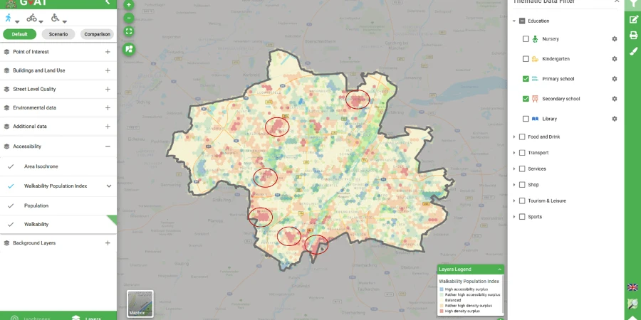
In this example (figure 2), GOAT shows, in red color, the areas where the population density is high but the access to schools is low, making residents travel more time to reach their respective education facilities. The construction of new schools in these areas would increase the accessibility and enhance the non-motorized trips to school in these areas.

Figure 2. Comparison of Accessibility and Population Density for primary and secondary schools
In figure 3, a zoom-in in one of the red zones where the 15-minutes walking isochrones show the uncovered housing area; as a possible solution, it is possible to assess the impact in accessibility after implementing two new schools in the uncovered area. As a result, the study area now looks more balanced, and the affected area now has higher accessibility to schools.

Figure 3. Scenario analysis for new schools
Number and variety of amenities
GOAT can also calculate the total number of amenities per type within a specific walking point. This type of analysis would be advantageous when you are planning to move and want to make sure you have access to your desired amenities, like groceries, shops or restaurants. The next picture (figure 4) presents a small assessment example of a possible potential housing location.

Figure 4. Isochrones and amenity counts
As shown, GOAT has vast potential for assessing accessibility conditions in cities, and therefore, to be used as a tool to plan 15-minute cities. The use of pedestrian networks, the transfer to many different environments, and the diverse indicators are some of the features that GOAT has in order to understand the urban environment and enhance walking and cycling conditions. To get more information about the different functionalities, please visit our tutorial page, or try our demo versions at current implementations.
References
C40 Cities (2020): C40 Mayors Agenda for a Green and Just Recovery.
Frank, L. D.; Sallis, J. F.; Saelens, B. E.; Leary, L.; Cain, K.; Conway, T. L.; Hess, P. M. (2010): The development of a walkability index: application to the Neighborhood Quality of Life Study. In British journal of sports medicine 44 (13), pp. 924–933. DOI: 10.1136/bjsm.2009.058701.
Geraint, Ellis; hunter, Ruth; Donnely, Michael; Kelleher, Luke; Kee, Frank (2015): Connectivity and physical activity: using of footpath networks to measure the walkability of built environments. In Environment and Planning B: Planning and Design 42.
Moreno, Carlos (2019): The 15 minutes-city: for a new chrono-urbanism! Paris. Available online at http://www.moreno-web.net/the-15-minutes-city-for-a-new-chrono-urbanism-pr-carlos-moreno/, checked on 12/1/2020.
SDP Bogotá (2020): Una ciudad de 15 minutos donde se priorice al peatón. A 15-minute city where the pedestrian is prioritized. Available online at http://www.sdp.gov.co/noticias/ciudad-de-15-minutos-donde-se-priorice-al-peaton, updated on 8/31/2020, checked on 12/1/2020.