MobiData BW Hackathon
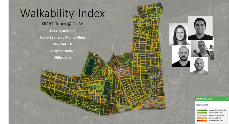
Last year we participated in the MobiData BW Hackathon and were one of the winning teams with our “Walkability Index”! Our team members were Elias Pajares, Ulrike Jehle, Majk Shkurti, Grigorii Ivanov and Rafael Leonardo Munoz Nieto.
The Hackathon took place on 27.-29th November 2020 and was organized by the Ministry of Transport of Baden-Württemberg, the City of Freiburg, and the Public Transport Company of Baden-Württemberg. The event pursued the goal of developing new solutions for future mobility. In total, 150 participants were tackling 30 different challenges. Since sustainable future mobility is something that we also aim for, we were happy to roll up our sleeves and start coding for a good cause!
The Course of the Event
Inspiring input talks on Friday marked the perfect start of an exciting event which went on with the presentation of the different challenges. This was followed by the team building, then the main programming and finally, the working phase! On Saturday the minister of transport, Winfried Hermann, and the major of Freiburg, Martin Horn, participated in the event by initiating the working day with an encouraging wake-up call. After 36 hours of coding and very few hours of sleep, we were excited to pitch our results on Sunday.

Following the presentations of individual groups, the jury evaluated them based on the following criteria: Contribution to the sustainable mobility in Baden-Württemberg, innovation level and creativity, reference to data and resources, feasibility, and the presentation of the results.
Our Challenge: “Walkability Index”
We tackled the challenge “Walkability Index” and developed a respective prototype and an algorithm to calculate potential pedestrian flows.
As one of the lucky winners, we receive a 3-month funding from the Ministry of Transport Baden-Württemberg as part of a follow-up grant to the “MobiDataBW Hackathon 2020” hackathon to establish our developed prototype.

Innovation Phase
The 3-month founding period, called the innovation phase, started at the beginning of March and lasts until Mai. Within this period, we aim to improve our prototypical WALKability IndEx under the acronym WALKIE.
Our solution is to visualize the walkability per route segment by considering multiple factors such as the quality of the sidewalk, lighting, vegetation, and the neighborhood’s liveliness by the use of open data sources, such as OpenStreetMap and Mapillary. This index will then be interlinked with potential pedestrian flows to identify and prioritize necessary improvements in the walking path network.
We are developing the new features together with the City of Freiburg, which is our pilot city in this project. First, we will transfer GOAT with its existing functions and then gradually implementing the new features. We will announce the release on our website, stay tuned to be one of the first to test it!
As we strongly believe in the power of open data, the developed algorithms will be available on GitHub, and all collected data directly published in Mapillary and OpenStreetMap.
Project Benefits
With the implementation of WALKIE in GOAT, we aim to evolve GOAT into a comprehensive, innovative planning tool for walking analysis. The tool identifies existing weaknesses and points out potentials for improvement of the pedestrian network, which can be remedied by municipalities with targeted measures to promote more active and sustainable mobility. In the long term, this Walkability Index could also be applied to bicycle traffic and barrier-free accessibility, thus the ride comfort for these two modes of transportation could be incorporated into the planning tool. It is easily transferable to other cities and a statewide promotion of active mobility can be achieved by applying the tool to other cities and regions.


